

|
|
It's May and officially the start of the Spring-Summer storm season when longer days and stronger solar heating encourage proper inland convection with the promise of perhaps the first proper storm cells of the warm season. May is usually a good month In N. Ireland with settled periods with early HP heat wave patterns not being unusual, just think back to this time last year when we had that incredible period of warm weather and endless sunshine. 2021 has been very different, in fact, the synoptic pattern for the first half of the month has been indicating an unsettled period with cooler than average conditions. When I did my check through the models I noticed a high frequency of days showing Nly or Ely flows associated with HP rooted to the far north, this was not a good sign at all, it meant cooler temperatures, night frosts and no hot weather.
For storm lovers in N. Ireland it can be a bad thing because if the Nly breeze is strong enough then CAPE often gets shunted much further south with the Republic getting the storms and we miss out. My heart sank at the prospect of a poor convective Spring as I had been waiting all year for this time anticipating those days of hot weather and storm chasing, I was actually thinking it could be at least June before I would have a chance of seeing any dramatic skies and that was just too long a wait. However, as we entered May the models began to show episodes of weak to moderate instability and that Nly flow looked light, the days looked showery but solar heating would be plentiful and as a result the charts indicated an entire week or more of set-ups which were worth watching, at last after a long wait I would be getting treated to potentially daily chases.
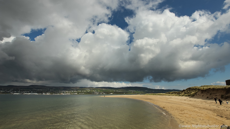 |
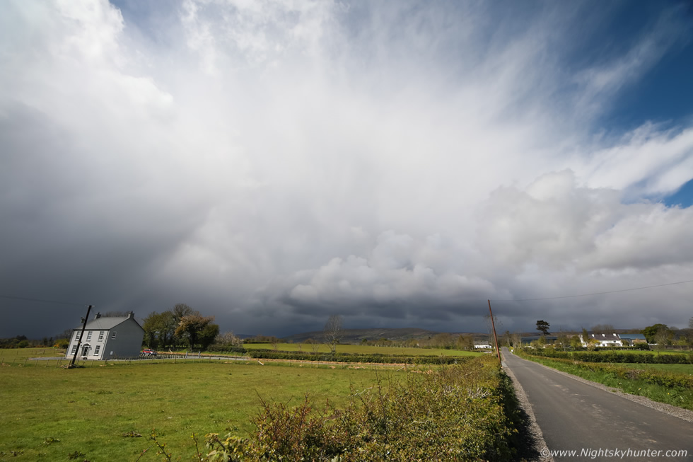
On May 1st a low risk convective outlook had been issued for northern regions of NI. The CAPE was so weak I paid it little attention however there was surface convergence expected which could trigger a few convective showers and with calm conditions it seemed there could be a chance of something so I decided I would keep an eye on the sky while undertaking other filming work. I was up very early this morning filming along the Co. Antrim coast and had noticed development of Towering Cumulus over Co. Donegal. I drove to Magilligan Point which looked like a good place for a front row seat of the action. I noticed that the clouds were very slowly moving from W to E over the hills but there was also low level cloud feeding in from the ocean to the N. I was immediately on high alert because this was a classic example of a sea breeze convergence zone. It was such a gorgeous morning with very strong sunshine, the clouds were bubbling up merrily and I noticed that line of towers acquiring proper vertical development which took me by surprise. They were not tall enough for thunder however they did have a beefy look which is always a positive sign. This is a wide angle image of those early towers, these were almost stationary but had slight L to R motion, keep in mind the invisible sea breeze was gently moving in from the right interacting with those bases. The scud below was begriming to rise all across the base so these towers were still breathing in inflow, all the signs were looking good.
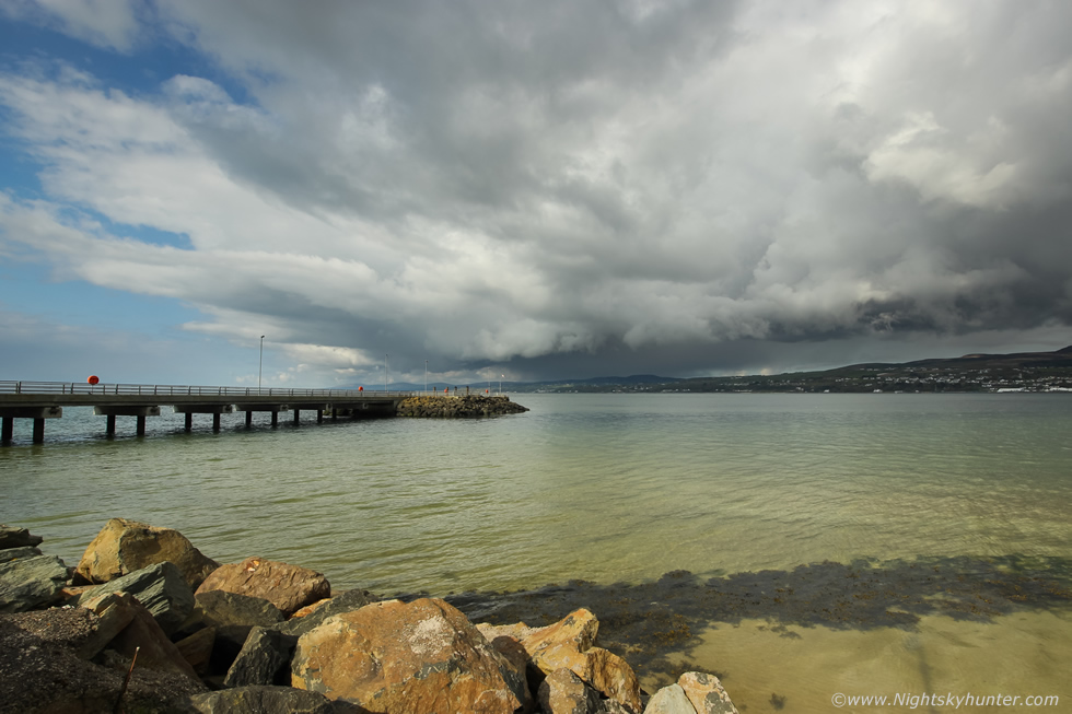 |
A little later the convective line was evolving. The N or R side had those towers with inflow while the W or L side had developed light showers and was now clearly outflow dominant. This side had a weak shelf cloud forming which looked quite cool over the vibrant orange and green water with Magilligan Pier in the foreground. I set up the Canon 600D with 10mm lens and began shooting a time lapse. This was ironic because earlier in the morning I had been complaining to photographer Nigel McFarland about what a terrible year 2021 had been for sky action so far and that I hadn't even shot a single convective time lapse this year. Now I was standing in the sun time-lapsing and I was absolutely loving it, I felt like I was back in the zone once again.
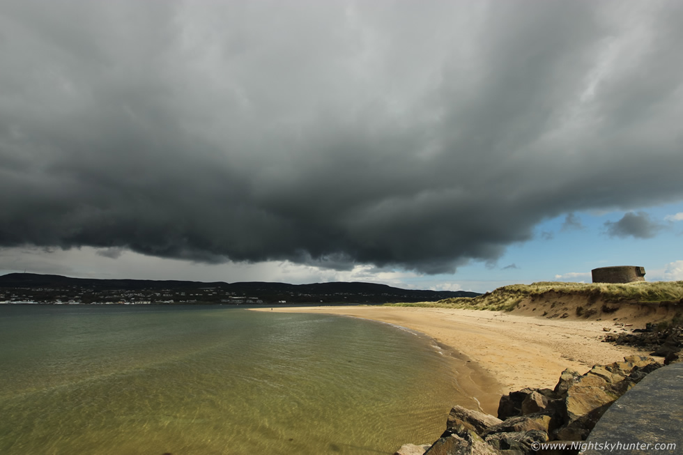 |
As the camera worked away I turned my attention to the R side of the line. If you know anything about convection then this was the place to be watching, it was still showing strong inflow motion and there was no rain and with the convergence (Cz) at play this was the place to watch for funnel clouds. I wasn't actually expecting to see any until the clouds became agitated and suddenly came to life. Two areas under this base began rotating consistently, I was impressed, but expected it to die at any moment but the longer I watched the more the two areas of rotation kept up their spinning. I resisted grabbing the other camera and just watched visually for a while then the temptation to act became too strong so I stopped the time lapse and snapped this 10mm still of the scene.
 |
I switched to the 18-55mm kit lens to get in closer, the right circulation seemed the most active so I aimed the camera in that direction. That entire cloud base above the person on the beach was rotating counter clockwise. I then began shooting another time lapse of this scene. As it turned out this base had rotation in the same area for 30 min's! I have never seen rotation last this long in my life from any thunderstorm so this was a rare treat. I let the time lapse run hoping for a funnel then suddenly in my periphery I saw one!
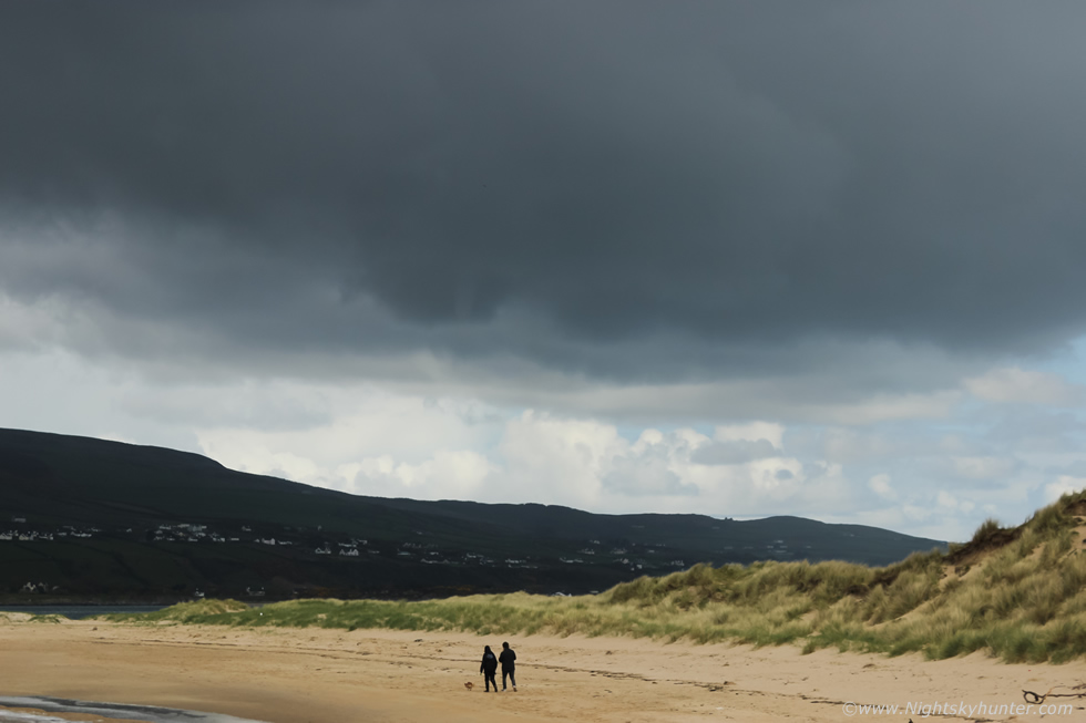 |
Unbelievably it was out of frame to the right under the leading edge of the line. I lifted the camera off the tripod and began shooting stills as fast as I could. The funnel can be seen above the walkers near the centre of the frame, it was short but had a transparent white tube and could clearly be seen rotating. I had it in sight for perhaps one minute then it vanished. It was a small unimpressive specimen but it was a funnel nonetheless and my first sighting of the year so I was overjoyed, it actually felt like a little gift from the Universe.
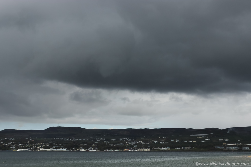 |
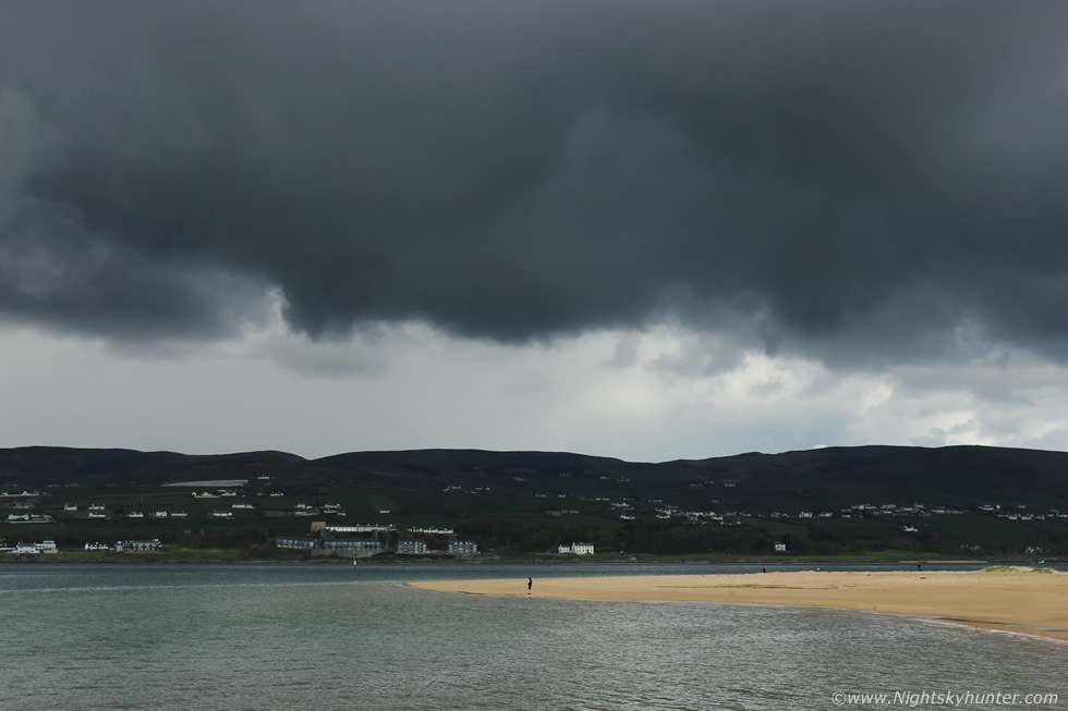
Then amazingly five min's later another funnel formed, this time from the middle of the line which was now closer and rite over Lough Foyle. It was short and stubby but at fairly close range to me, its snout angled slightly towards me so it appeared foreshortened and it was rotating like mad, you can see it in the above image with cloud wrapped around the vortex, I even managed to shoot a very short time lapse.
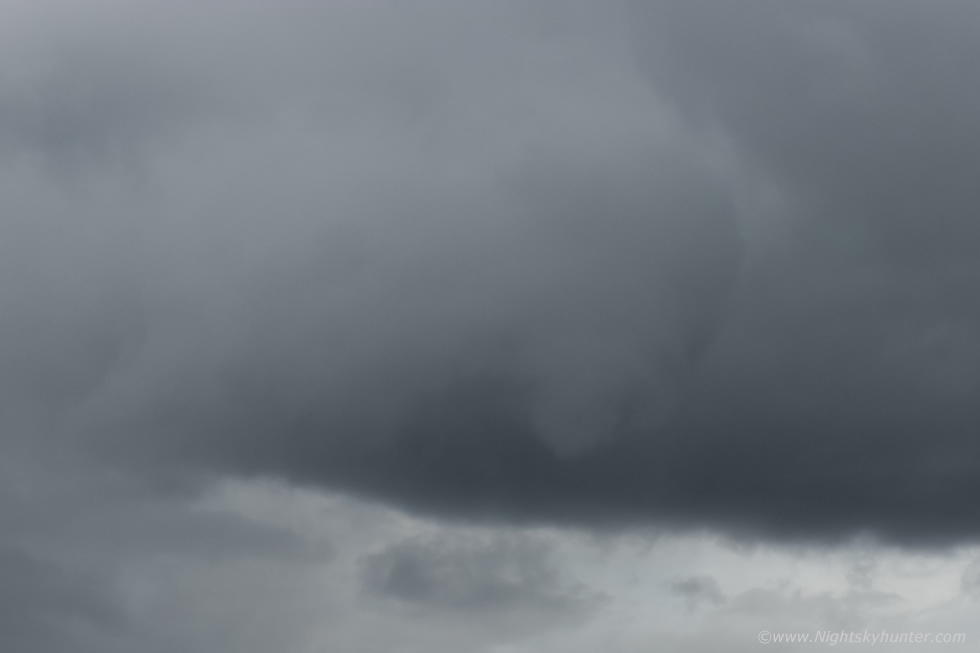 |
Cropped in showing the collar cloud wrapped around the funnel, this was cool, but I kept thinking, what if there had been stronger CAPE, this could have went all the way down and been a close range waterspout on Lough Foyle. It then vanished, I considered myself very fortunate to have witnessed two funnel clouds within five minutes from the same location. This sighting also marks a new personal record as the earliest funnel sighting I have ever had, the time was just after 10.30 in the morning. It just goes to show never under estimate weak CAPE set-ups on days with good solar heating, light winds in conjunction with sea breeze convergence zones. May had got off to a good start, I was finally back in action.
 |
On May 9th we had our first 'proper' set-up of the year with a Sly flow warm sector with 400-500 CAPE, shear profiles were very impressive with 40-50 knots of deep layer shear (DLS) and even backing winds in the afternoon causing directional shear. This combined with low bases prompted many convective outlooks and a convective discussion from TORRO. The synoptics favoured storms with supercellular traits and a risk of tornadoes. It was exciting to get such a dramatic forecast so early in the season however as my friends and I studied the details we had some reservations about the potential. First of all was the fast wind speed, with 15-20mph surface winds and over 40 knots of shear aloft then cells would be moving extremely fast which meant chasing them would be very difficult, the idea would be to get into position and watch for developments on radar then stay ahead then let them approach, once they passed it was game over as chasing these swift cells with our road network wasn't viable, this speed also ruled out any time lapse photography.
The other issue was the skew-Ts which showed the temp and dew point lines meeting at mid levels with rich moisture, we suspect cloud tops could be restricted in places, also upper air profiles were only -10C to -20C which was very borderline, I would have preferred colder air so overall I was already anticipating warm looking low tops. The CAPE only peaked mid afternoon then began to reduce by late afternoon then shift to the far NW. We needed a lot of luck to overcome these issues and clearing clouds to get solar heating to work fast. After mid day the front cleared and the cloud began to break, solar heating was great and I could feel the humidity in the air, I noticed showers forming on radar to the S which already looked sheared, one was heading for Omagh, the cell was approaching the border and would be moving fast so I got on the road for a big chase.
Less than one hour later I was outside Omagh and had pulled over to admire the sky, my timing at been good, I had intercepted that cell which was already here. I didn't know it then but this would be my only photogenic prize of the day. This cell was massive in length and extremely sheared, its anvil and precip where blown all across the Sperrins for miles downwind, the base was low to the ground and it looked mean. This tilted updraught and anvil was experiencing 40-50 knot winds aloft. I got phone calls from John Fagan and Paul Martin discussing it, Owain Rice also text me saying it looked very well sheared on radar and even had hints of a mesocyclone. I took this shot with the 18mm lens then set about changing to a wide angle, when I looked up again the cell was already across the Sperrins and distant, that's how fast this was moving.
Soon after I met Paul Martin in Omagh then we chased together, cells began to erupt on the W and NW coast, Killybegs had the first sparks of the day and more formed over Co. Donegal. Paul and I chased into Donegal and parked up on a back road in the middle of the Irish countryside which offered a great view across the sea and hills, we spent the rest of the day here. We could see several active storms then later a third at closer range however the sky was not photogenic at all. The cells looked messy with no structure, their tops were short and warm looking, even mushy and bases were high. Furthermore the sky was grey with a lot of low cloud blocking the view and we had so many heavy showers we spent much of the time in the car, it was like a wet Autumn day. Nigel McFarland joined us for the chase, we kept an eye on the sky and saw a nice low level rainbow but we never took the cameras out of the bags at all. We did however get the drones in the air which was quite a buzz, Paul flew my Mavic 2 Pro while Nigel and I flew Paul's Phantom 3 Pro, this was a good way to pass the time and keep the drone skills sharp, after this we called it a day and returned home feeling exhausted and a little let down by the day, but being optimists we were already looking forward to the next chase.
 |
The following day May 10th offered another chance, the synoptics were very different so I had hopes for more photogenic skies. This was post-frontal, the surface breeze was 10-12mph from the SE and upper air was much better at -40 C. There was no shear at all so cells would be pulse type and would turn messy however if I got on them early and if we had good heating then I expected to see good towers and cbs which could be camera-friendly. These set-ups normally have good visibility so I decided I would prefer that to the skies we witnessed the previous day, a last minute check showed saturated profiles again but I ignored this and decided to make the most of the day. Cells formed rapidly on radar and by the early afternoon they were everywhere, I took a back road to Maghera not far from Five Mile Straight to get a better look at this one. Not exactly photogenic however the dark sky, white anvil and sunlit fields made for nice contrast. This was coming straight towards me, you can tell from the wispy anvil that his was not a strong cell. I arrived in Maghera just as it arrived and ended up under a very intense slow moving downpour which dropped a lot of hail, once it passed the gutters were filled with hailstones.
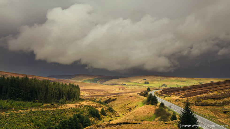 |
I parked at Oak Leaf filling station on Glenshane for refreshments to watch the sky, I watched a cell approach and soon I was under the most intense downpour I've experienced this year. It was like driving at high speed through torrential rainfall with rain and hail lashing the windows, only I was parked stationary. Once it passed I followed it to the top of Glenshane Pass, I got the drone up for a view of its flanking area. This was the massive cell, you can make out its dark precip core just over the other side of the hills, then the cloud broke overhead and sunlight lit up the landscape with glorious warm light which made for a dramatic moment worth capturing. Later I watched a storm pass over the Sperrins from the Moyola River however there was no structure on offer, too many cells were on radar with their outflow killing one another so it was a messy scene, at 17.00 I made my way home.
 |
May 12th looked to be a promising forecast with a SWly flow, moderate CAPE lasting to evening, strong solar heating with limited cloud cover, good lapse rates, -30C cloud tops, no wind shear however there would be several convergence zones across Mid-Ulster which could tip the scales. TORRO had issued a Convective Discussion with N. Ireland in the box, the main risk was funnel clouds and weak tornadoes. My hunger was strong to catch something photogenic on camera so I was beginning to feel that pressure one gets during the early stages of the storm season to get off the starting line with something either photogenic or dramatic. This is a personal thing and I know other chasers feel it too, that desire to capture something special, after all, the convective clock is always ticking and there are a limited number of storm days each year so the excitement and anxiety in this field can be quite high.
Speaking for myself, if I haven't seen any decent skies by the end of May then I tend to end up chasing my own tail and end up in a mental mess, but if I do succeed I tend to feel more content and settled with a more calmer head, if I have something cool 'in the bag' then I continue the rest of the storm season in a more confident tone when I truly feel in the zone and one with nature. I have always said that if you want to see something special in nature, be it a great aurora or a funnel cloud then you need to put in a lot of hard work and dedication. You need to show Mother Nature that you really are passionate about what you do and if you keep at it, take the busts, and keep remaining faithful to the sky then sooner or later nature will reward you.
Today I was at the stage were I felt like nature owed me, even Roisin said so herself, I had been single minded in my quest to capture dramatic skies but most important I wanted a proper funnel cloud. The last time I had observed a decent specimen was back on June 24th 2016 when Conor McDonald and I watched a nice slender rope from outside Mahera. I have seen others since then but they have been short or unphotogenic. To be honest I was feeling let down by 2021, it seemed to be completely devoid of any decent sky action and I was already saying to Roisin that this has been the worst year I have ever seen, even the recent chases confirmed it, however I remained optimistic and decided to chase and be on guard.
For the first time this year I noticed that the sky was 'talking', it looked good and it felt good too, the air was warm and humid, even the low clouds were warm looking, it felt like something could happen. I prepped my gear, two cameras charged and ready, telephoto lens, drone, tripods and water supply. I needed to head to Maghera first as I wanted to visit my Mum and cut the garden for her while the weather was still dry. Just as I left home in Cookstown I knew something was going to happen, the sky was dark and heavy with several long black bases close to the ground going rite across the Sperrins, but I let it go and headed to Maghera. When I checked the internet I was shocked to learn of a funnel cloud captured near Fintona in Co. Tyrone, likely from the very same bases I had been watching before I left, I was gutted and realized I had missed my chance of the day. In the afternoon I was mowing the lawn and I got it 95% finished before heavy rainfall arrived from an outflow dominant cell so I took shelter in Mum's house. The rain seemed to fall for a long time and by the time it stopped outflow had killed anything from happening for the rest of the day.
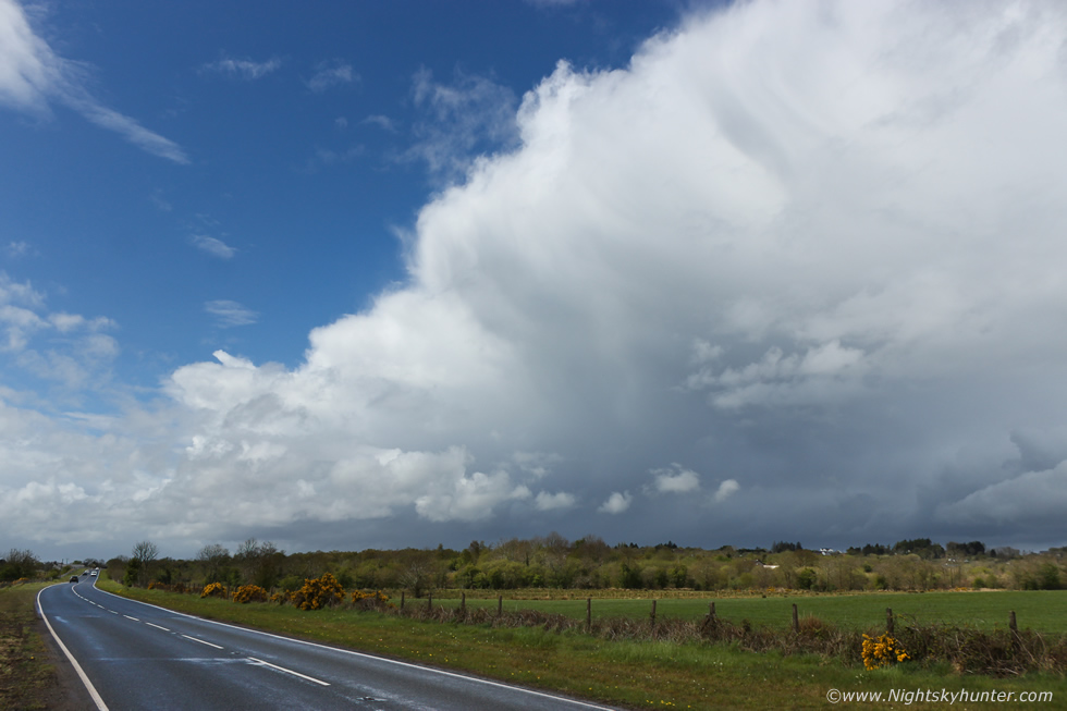
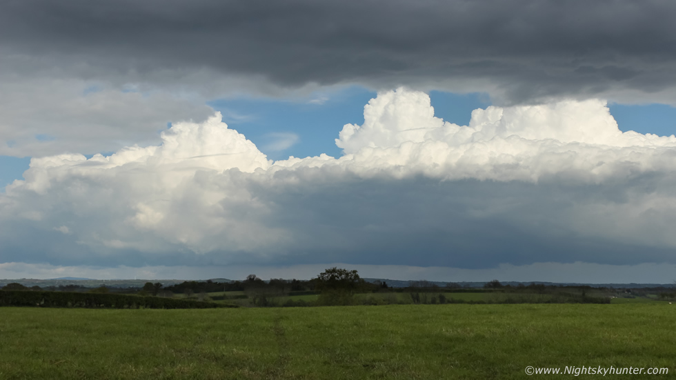
A clearance revealed distant convection to the E so I drove outside of town into the Maghera countryside to an old favourite spot to watch the convection. There was a line of very nice towers, the updraughts were crisp and the long rain free base had that look that warranted watching. A funnel could form below any of these towers at any moment, so I ended up leaning on a gate with camera gear watching for over an hour and nothing happened, the above image shows these updraughts. The sky seemed quiet and I figured the best had already happened so I drove back to my Mum's house and suggested we go for a walk, my Covid jab was later in the evening and I had time to kill so we decided we would make the most of it and took our Dog Rhua with us too. But where to go? I wanted somewhere in the countryside that was away from the town which also had a good view of the sky so I could keep an eye on the clouds (old habits die hard), then I heard Roisin's voice in my head, on the previous night we had been discussing places to walk near Maghera when Roisin suggested Slaughtneill football pitch, I thought that was a good idea, so now we made our way to Slaughtneil.
We arrived and got out for a walk, it was warm with good pockets of solar heating, I spotted two distant towers over the Sperrins then lost them from view as the sky had now become quite cloudy. We began our walk and were having a good time when I began to get that feeling that I should have brought my camera and long lens with me just in case, I shook it off, after all they were in the van and I could run and get them if needs be. We completed our walk and returned to the car park. It was then that I had an instinct that something was going to happen, it was dead calm with no breeze but I noticed that the clouds were slowly moving in different directions, there was a distinct flow from the N which seemed to meet the clouds over the mountain in front of us, this was yet again a classic sea breeze convergence zone. A convergence zone is when wind from opposing directions meet, this 'convergence' becomes a source of lift which can help generate convection and also aid with rotation. Vorticity can form along a horizontal plain and if a strong updraught is within this region then the horizontal vorticies can get tilted into a vertical aspect by Towering Cumulus and developing Cbs, this can lead to funnel clouds and convergence zone land spout type tornadoes, and now I was watching this very process in action.
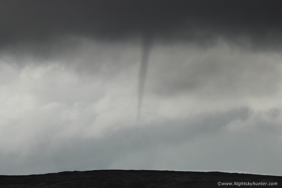 |
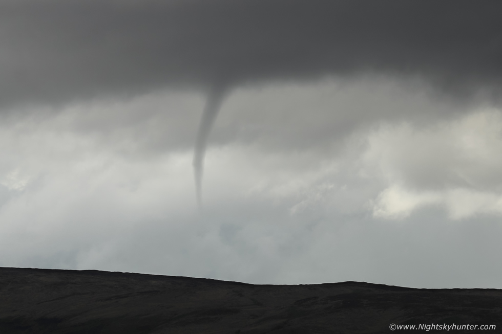
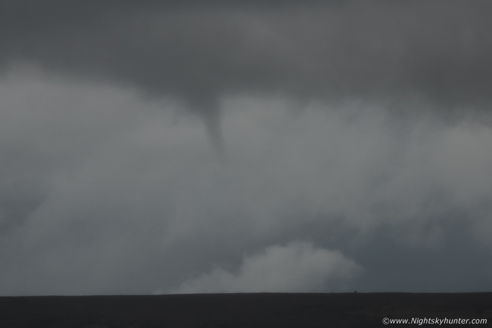
I looked over the mountains, then turned around to look at the blue sky to the E, then I turned back to the W and looked over the mountain again - Holy S##t!!! - I yelled ''FUNNEL'', I was in utter shock, a striking funnel cloud had suddenly manifested like an apparition. I was momentarily panic struck as often happens when a good funnel appears, you spend hundreds of hours over years hunting for these things and mentally rehearse exactly what you will do when it happens but it when it does all that goes out the window, it's an avalanche of shock, awe and emotion and you can get rooted to the spot.
Those first few seconds felt like an hour in slow motion, like the nightmares I sometimes get when something cool happens in the sky and I can't move or my camera is gone or doesn't work. I snapped out of my trance and opened the side door of the van and grabbed the Canon 600D crop sensor, took off the 10mm lens and switched to the 18-55mm kit lens. I fired off two images, at least I got a record but the wide field of that lens didn't do it justice, I needed to get in closer. Funnels can last for seconds or a few minutes, or more rarely tens of minutes, but more often than not they vanish very fast, I wondered would I have time to change lenses again, I looked up and it was still there, I took the chance and attached the 100-400mm and zoomed in while holding the lens with trembling hands, once I got that first close up image I was delighted, I knew I had it and any other images I got would be icing on the cake, I expected it to vanish but it didn't, it stayed in full view of Mum and I so I began shooting as many images as I could. The funnel was completely straight. shockingly so, almost like a dagger hanging from the sky and completely stationary, it really was amazing.
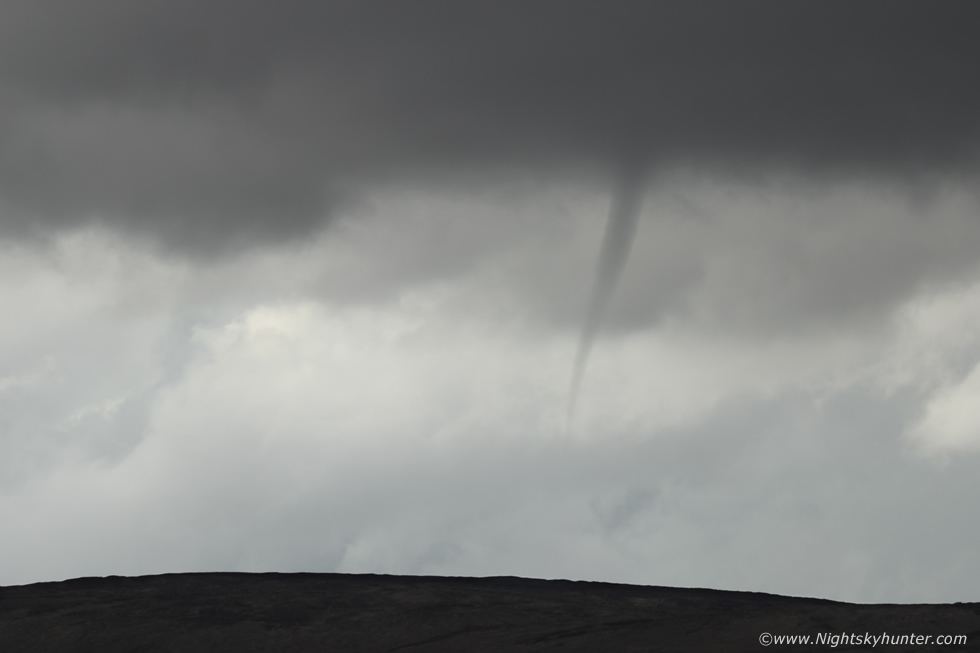 |
From our perspective it was hanging over the summit of Cairntogher and perhaps slightly on the other side, below the image was Slaughtneil football grounds.
 |
This was the location back in 1997 when I saw great comet Hale-Bopp for the first time which changed my life forever, and now quite by chance here I was again standing on these very same grounds watching a rare funnel cloud in the sky.
 |
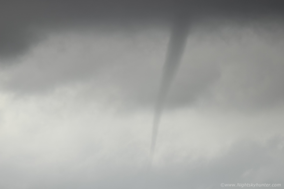
If you look carefully you can see another transparent vortex inside the main funnel marked by a dark edge either side. Through the camera's viewfinder I could see it rotating away while bulging and contracting, I was buzzing yet at the same time in awe that it was still visible.
 |
If you have never seen a good funnel cloud before then you are in for a treat, but I should issue a word of caution, these things will also change your life, the experience is so profound and unique that you want to feel those sensations again so you will end up obsessing and wanting to capture more, which is a good thing, because you will end up fascinated by thunderstorms and our weather systems.
 |
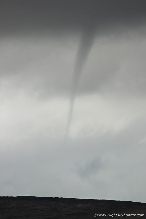
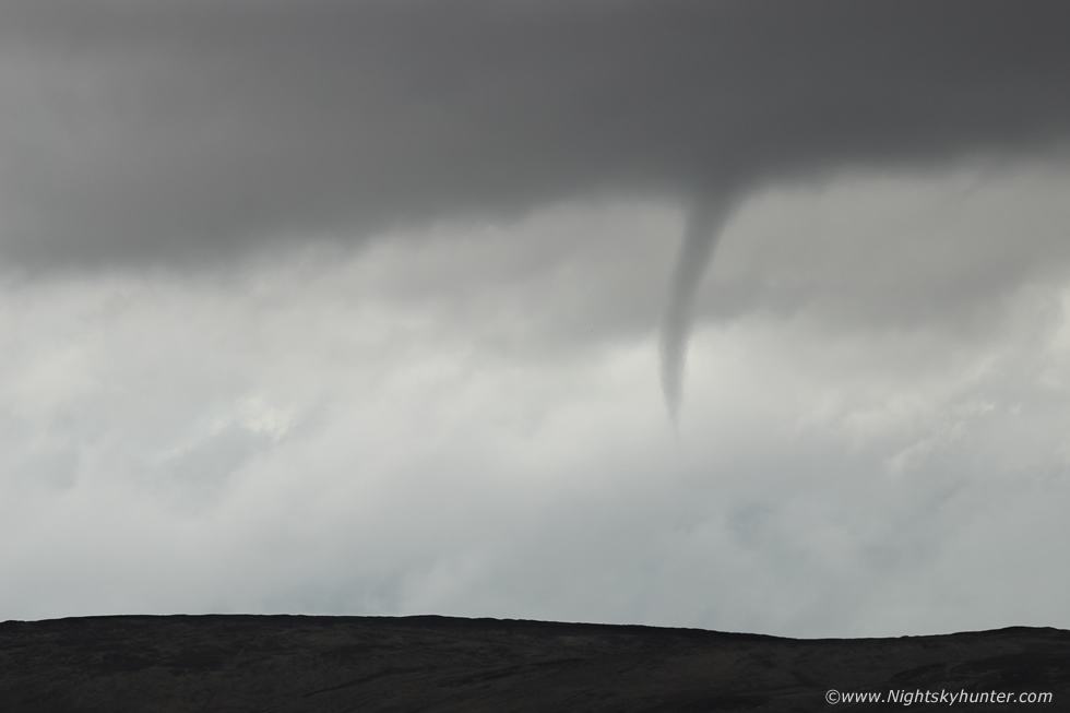
The funnel then evolved into a graceful curve, I had time to take plenty of images and point it out to my Mum and explain what it was, she was in awe of it just as much as I was, even Rhua was sitting on the ground looking towards the mountain trying to figure out what it was we were so excited about.
 |
I was so tempted to start taking video but I had a feeling my hand would be too shaky at this focal length so I stayed committed to still images. I was delighted my Mum was with me to witness this rare sight from nature, the last time she observed a funnel cloud with me was back in 2009 at Ballyronan Marina so this was a special moment.
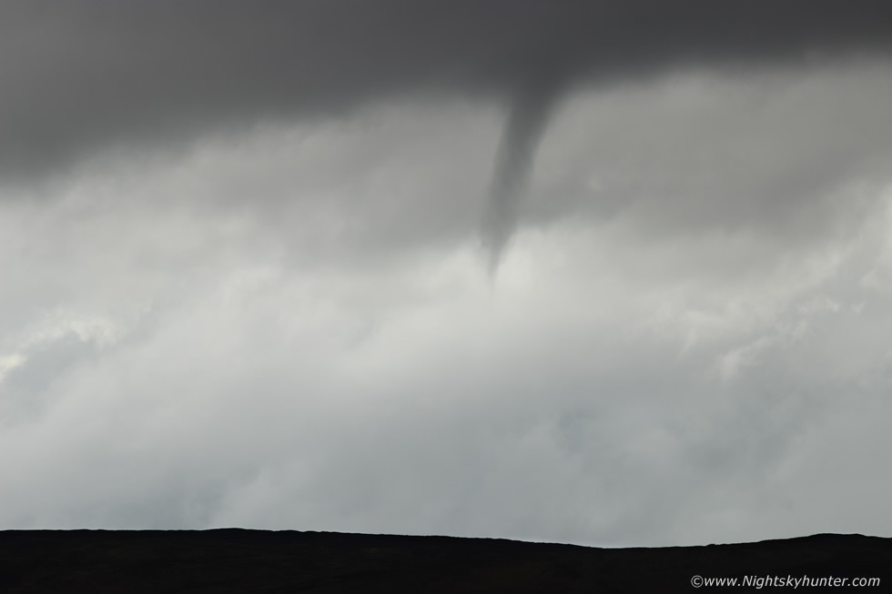 |
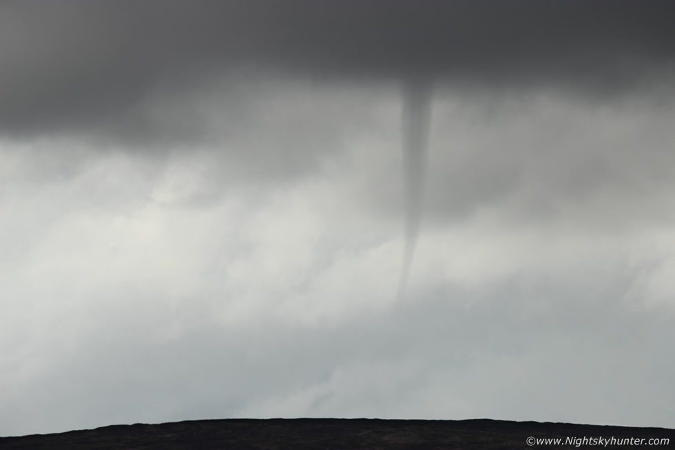
The funnel began to lift, it would soon vanish, they either disappear, retreat back into the base or rope out. This was one lifted then vanished, but before it did so it revealed interesting structures.
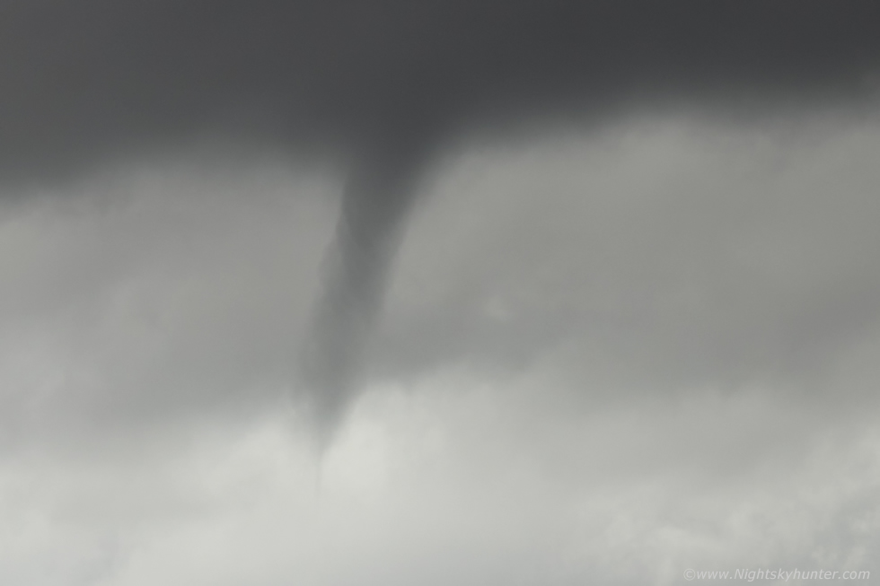 |
This is a crop, check out the swirls of cloud revealing the swift rotation inside the vortex. The apparition ended then Mum and I stood there in silence as if in respect for what had just happened. Then I held my fist in the air and said ''yesssss!!', I was elated. The funnel had first appeared at 17.40 and remained visible for five minutes. This was the best funnel I had captured in years and it also broke a new record for me. The Lough Foyle twin funnel event was the earliest funnel sighting I've ever had and I believe this one to be my latest, however it wasn't far of the time of the big funnel of 2007, the timing could be close, but I think this one was a fraction later. As it turned out there were several other sightings from the local area and at least two others captured it on camera from different angles, one from Maghera and the other from Knockloughrim, it was a very well defined highly visible event and although it didn't touch down it did have an exceptional length, if the cloud height was determined and triangulation between several observers taken into account then an approximate funnel length could be estimated.
 |
The show was not over for Mum, Rhua and I, we had retreated inside the van as it began raining but that area of interest was still in the same location so I suspected another funnel could be possible and I was correct. Funnel number two appeared at 18.10 and again it lasted for five minutes. This one wasn't as large or photogenic but it could clearly been seen over the mountain, furthermore I was shooting through a curtain of rain, precip was actually soaking the lens as I leaned out the open window to get this capture. Two funnel clouds within 30 minutes of one another in the exact some spot was an unexpected treat, this event has turned the tables around, 2021 is now back in form and so am I.
Over a period of 48 hours between May 12th and 13th there were at least five funnel clouds captured from N. Ireland. The two Maghera funnels, a single funnel from Lough Fea direction, another from Fintona and a large rope in Newry which was seen by John Fagan and captured on camera by a local, the funnel was close to the ground and significant, a touch down hasn't been ruled out. The storm season is well underway and I have more chases planned, perhaps 2021 has more exciting storm surprises in store, until then, thanks very much for reading.
Martin McKenna